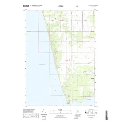
2019 Map of Flower Creek
USGS Topo · Published 2019About this map
Lake Michigan dominates the western edge of this coastal landscape, where the sandy shorelines of Muskegon and Oceana counties meet. The shoreline is defined by notable geographical markers like Indian Point and Long Point near the mouth of White Lake, which opens into Indian Bay. Further north, the namesake Flower Creek and Little Flower Creek meander toward the lake, carving drainage patterns through a mix of forested terrain and rural grid roads.
Find a feature on this map
67 named features on this map. Tap any name to fly to it.
Don’t see what you’re looking for? This feature index may not catch every label — zoom into the map to look around manually.
Map Details
Editions of this 2019 Flower Creek Map
This is the sole edition of this map. No revisions or reprints were ever made.
Other maps of this area

1929 · Montague
USGS Topo · 1:48,000

1931 · Hart SE
USGS Topo · 1:31,680

1954 · Milwaukee
USGS Topo · 1:250,000

1958 · Milwaukee
USGS Topo · 1:250,000

1959 · Montague
USGS Topo · 1:62,500

1959 · Hart
USGS Topo · 1:62,500

1976 · Montague NW
USGS Topo · 1:24,000

1976 · Montague SW
USGS Topo · 1:24,000
1976 · Hart SE
USGS Topo · 1:24,000
1976 · Montague NE
USGS Topo · 1:24,000