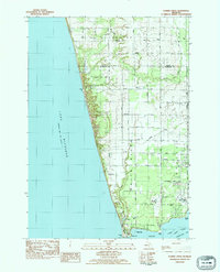
1983 Map of Flower Creek
USGS Topo · Published 1983About this map
Lake Michigan forms the western boundary of this coastal region where the White River meets the shore. The landscape is defined by the transition from the Manistee National Forest in the northeast to the developed recreational and agricultural lands further south. The Old Channel and Indian Bay near the river mouth highlight the shifting hydrology of the area, punctuated by landmarks like the Pumping Station and several small cemeteries including Mouth Cem and Hubbard Cem. Local infrastructure is visible through the Chesapeake and Ohio railroad line and a network of rural roads such as Skeels Rd and Meinert Road. The presence of the Old Channel Trail Golf Course and parks like Meinert Park reflects the mid-century growth of this shoreline into a recreational destination for the surrounding counties.
Find a feature on this map
47 named features on this map. Tap any name to fly to it.
Don’t see what you’re looking for? This feature index may not catch every label — zoom into the map to look around manually.
Map Details
Editions of this 1983 Flower Creek Map
This is the sole edition of this map. No revisions or reprints were ever made.
Other maps of this area

1929 · Montague
USGS Topo · 1:48,000

1931 · Hart SE
USGS Topo · 1:31,680

1954 · Milwaukee
USGS Topo · 1:250,000

1958 · Milwaukee
USGS Topo · 1:250,000

1959 · Montague
USGS Topo · 1:62,500

1959 · Hart
USGS Topo · 1:62,500

1976 · Montague NW
USGS Topo · 1:24,000
1976 · Montague SW
USGS Topo · 1:24,000
1976 · Hart SE
USGS Topo · 1:24,000
1976 · Montague NE
USGS Topo · 1:24,000
Featured Places
- Montague, MI
- Montague Township, MI
- Claybanks Township, MI
- White River Township, MI
- Fruitland Township, MI