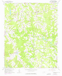
1964 Map of Flowers
USGS Topo · Published 1976About this map
Buffalo Creek and Cattail Creek carve through this Johnston County landscape, defining the rural character of the Wilders and O'Neals districts. The map documents a mid-century agricultural community anchored by a dense network of country churches and family cemeteries, such as Hocutt Cem and Eason Cem. This 1964 survey, with purple revisions from 1973, reveals the transition of the region, noting the Corinth Holder High Sch and the Flowers Ranch Landing Strip as modern fixtures amid older settlements. Small communities like Archers Lodge, Emit, and Hocutts Crossroads serve as local hubs, while Wendell Lake and Cattail Lake provide significant water features. The southern edge is defined by the Neuse River, where the terrain begins to slope toward the river bottoms near Camp Atkinson.
Find a feature on this map
46 named features on this map. Tap any name to fly to it.
Don’t see what you’re looking for? This feature index may not catch every label — zoom into the map to look around manually.
Map Details
Editions of this 1964 Flowers Map
3 editions found
Other maps of this area

1902 · Kenly
USGS Topo · 1:62,500

1902 · Spring Hope
USGS Topo · 1:62,500

1903 · Kenly
USGS Topo · 1:62,500

1904 · Springhope
USGS Topo · 1:62,500

1953 · Raleigh
USGS Topo · 1:250,000

1954 · Raleigh
USGS Topo · 1:250,000

1964 · Flowers
USGS Topo · 1:24,000

1964 · Selma
USGS Topo · 1:62,500

1964 · Clayton
USGS Topo · 1:24,000

1964 · Powhatan
USGS Topo · 1:24,000