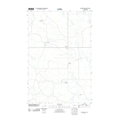
2011 Map of Flowing Well
USGS Topo · Published 2011About this map
Flowing Well and its eponymous Flowing Wells Rest Area serve as central landmarks in this high-plains landscape of eastern Montana during the early 21st century. The terrain is defined by a dendritic network of drainages, most notably Timber Creek, Crooked Creek, and Skull Creek, which carve through the dry coulees of McCone County. Man-made water management is a primary feature of the local geography, evidenced by several stock or irrigation dams such as Fradys Reservoir Dam, Gerold Gibbs Dam, and the numeric series including Frady Number 3 Dam. The transportation network is sparse, centered on the corridor of South Flowing Wells Rd and Green Trail Rd, reflecting the remote, ranching-oriented character of this region. The map also captures local place names like Patterson Coulee, providing specific geographic markers for researchers tracing land use and topography in the Big Sky Country.
Find a feature on this map
14 named features on this map. Tap any name to fly to it.
Don’t see what you’re looking for? This feature index may not catch every label — zoom into the map to look around manually.
Map Details
Editions of this 2011 Flowing Well Map
This is the sole edition of this map. No revisions or reprints were ever made.
Other maps of this area

1954 · Jordan
USGS Topo · 1:250,000

1956 · Jordan
USGS Topo · 1:250,000

1958 · Jordan
USGS Topo · 1:250,000

1964 · Jordan
USGS Topo · 1:250,000

1965 · Hedstrom Lake
USGS Topo · 1:24,000

1965 · Whiteside Ranch
USGS Topo · 1:24,000

1965 · Hedstrom Lake NW
USGS Topo · 1:24,000

1967 · Coal Creek
USGS Topo · 1:24,000

1967 · Frank Coulee
USGS Topo · 1:24,000
1983 · Flowing Well
USGS Topo · 1:24,000