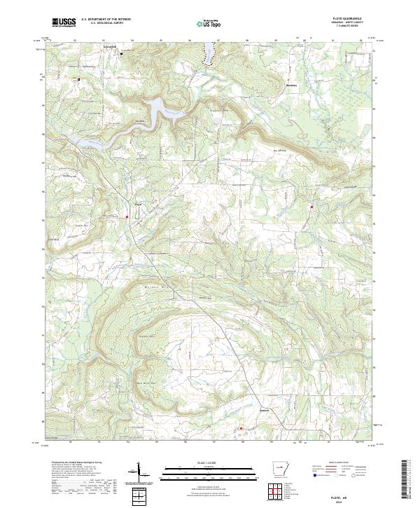
2024 Map of Floyd
USGS Topo · Published 2024About this map
Floyd and the surrounding White County uplands are characterized by a series of prominent ridges and peaks that overlook the winding course of Bayou Des Arc. The terrain is defined by named elevations such as Dugout Mtn, Des Arc Mtn, and Nipper Mtn, which rise above a network of smaller drainages including Cane Creek and Bull Creek. The map shows a rural landscape where small communities like Antioch and Gravel Hill are connected by a system of country roads and lanes, many bearing local family names. Genealogists may find value in the location of the Quattlebaum Cem and Gray Cem, while the inclusion of landmarks like Peanut Ridge and Red Rock Mtn illustrates the specific geological character of this region. The northern portion of the map is particularly water-rich, featuring Sutton Creek and Hog Thief Creek as they feed into the primary bayou system.
Find a feature on this map
116 named features on this map. Tap any name to fly to it.
Don’t see what you’re looking for? This feature index may not catch every label — zoom into the map to look around manually.
Map Details
Editions of this 2024 Floyd Map
This is the sole edition of this map. No revisions or reprints were ever made.
Other maps of this area

1953 · Memphis
USGS Topo · 1:250,000

1956 · Memphis
USGS Topo · 1:250,000

1956 · Russellville
USGS Topo · 1:250,000

1962 · Letona
USGS Topo · 1:24,000

1963 · Rose Bud
USGS Topo · 1:24,000

1963 · Garner
USGS Topo · 1:24,000

1963 · Floyd
USGS Topo · 1:24,000

1963 · Mount Vernon
USGS Topo · 1:24,000

1963 · Sidon
USGS Topo · 1:24,000
1963 · Beebe
USGS Topo · 1:24,000