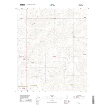
2020 Map of Flying H NE
USGS Topo · Published 2020About this map
Border Hill stands as a central geographic marker in this section of the New Mexico landscape, where the high desert terrain is deeply incised by a network of dry washes and canyons. The drainage patterns are clearly defined by Pine Tree Canyon, Monument Canyon, and the sprawling reaches of Little Twin Butte Canyon and Twin Butte Canyon. These topographic features dictate the movement of water and travel across the region, leading down toward the southern edge where Crooked Cr and Crooked Canyon traverse the border between Lincoln and Chaves counties. Minimal infrastructure exists here beyond the established tracks of Co Rd E028 and Co Rd E032, reflecting a land primarily used for ranching and open-range purposes. This survey provides a precise look at the land survey system and township boundaries that define property and jurisdictional lines in the modern era.
Find a feature on this map
19 named features on this map. Tap any name to fly to it.
Don’t see what you’re looking for? This feature index may not catch every label — zoom into the map to look around manually.
Map Details
Editions of this 2020 Flying H NE Map
This is the sole edition of this map. No revisions or reprints were ever made.
Other maps of this area

1955 · Roswell
USGS Topo · 1:250,000

1958 · Roswell
USGS Topo · 1:250,000

1961 · Flying H
USGS Topo · 1:62,500

1961 · Indian Bluff
USGS Topo · 1:62,500

1961 · Tinnie
USGS Topo · 1:62,500

1962 · Roswell
USGS Topo · 1:250,000

1962 · Horseshoe Bend
USGS Topo · 1:62,500

1979 · Roswell
USGS Topo · 1:100,000

1984 · Ruidoso
USGS Topo · 1:100,000
1988 · Sunset
USGS Topo · 1:24,000