
1961 Map of Indian Bluff
USGS Topo · Published 1964About this map
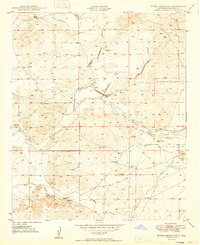
Indian Bluff stands as a prominent topographical feature in this section of the New Mexico high plains, where the border between Lincoln County and Chaves County bisects a landscape of deep canyons and seasonal water sources. The early 1960s ranching economy is clearly visible through numerous family-named outposts, including Corn Ranch in the north and the Waller Ranch and Waller Ranch East Camp to the south. This era relied heavily on groundwater management, evidenced by the distribution of sites like Barbara Well and East Cherry Valley Well.
Find a feature on this map
39 named features on this map. Tap any name to fly to it.
Don’t see what you’re looking for? This feature index may not catch every label — zoom into the map to look around manually.
Map Details
Editions of this 1961 Indian Bluff Map
This is the sole edition of this map. No revisions or reprints were ever made.
Other maps of this area
1949 · Hondo Reservoir
USGS Topo · 1:24,000

1949 · Juan Lake
USGS Topo · 1:24,000

1954 · Carlsbad
USGS Topo · 1:250,000

1955 · Hope NW
USGS Topo · 1:24,000

1955 · Kincaid Ranch
USGS Topo · 1:24,000

1955 · Roswell
USGS Topo · 1:250,000
1956 · Diamond A Ranch
USGS Topo · 1:24,000

1958 · Carlsbad
USGS Topo · 1:250,000

1958 · Roswell
USGS Topo · 1:250,000

1959 · Diamond A Ranch
USGS Topo · 1:24,000