
1959 Map of Diamond A Ranch
USGS Topo · Published 1985About this map
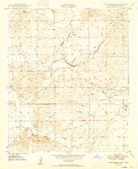
Diamond A Ranch and the nearby White Ranch define the ranching character of this Chaves County landscape, where water management is central to life in the arid high plains. The intermittent course of the Rio Hondo is flanked by an extensive network of ditches and levees, alongside a Gaging Sta for monitoring flow. A striking concentration of windmills and pump sites, identified here as mills, are scattered across the draws and arroyos. These include the Highway Mill, Eighteenmile Mill, Diamond A Mill, Center Mill, and River Mill. These features, alongside named drainages like Thirteenmile Draw and Rocky Arroyo, reveal a system of livestock support and water diversion typical of mid-century New Mexico land use. The map also traces Johnson Draw and Buchanan Draw, illustrating how the terrain was partitioned and utilized for large-scale ranching operations.
Find a feature on this map
18 named features on this map. Tap any name to fly to it.
Don’t see what you’re looking for? This feature index may not catch every label — zoom into the map to look around manually.
Map Details
Editions of this 1959 Diamond A Ranch Map
This is the sole edition of this map. No revisions or reprints were ever made.
Other maps of this area
1949 · Hondo Reservoir
USGS Topo · 1:24,000

1949 · Juan Lake
USGS Topo · 1:24,000

1949 · Corn Ranch
USGS Topo · 1:24,000

1950 · Corn Ranch
USGS Topo · 1:24,000

1955 · Roswell
USGS Topo · 1:250,000
1956 · Diamond A Ranch
USGS Topo · 1:24,000

1958 · Roswell
USGS Topo · 1:250,000

1961 · Indian Bluff
USGS Topo · 1:62,500

1962 · Roswell
USGS Topo · 1:250,000

1962 · Horseshoe Bend
USGS Topo · 1:62,500