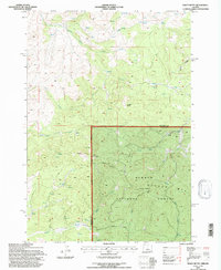
1992 Map of Foley Butte
USGS Topo · Published 1997About this map
Ochocco National Forest dominates the southern half of this landscape, where the Foley Butte Lookout stands atop the high point of Foley Butte. The terrain is defined by a dense network of high-elevation water sources and drainage systems, including the headwaters of Foley Creek and East Fork Foley Creek. To the north and west, the landscape transitions into a series of named peaks such as Sheep Rock and Aubrey Mtn, with numerous family-named or descriptive water points like Bills Spring, Rail Spring, and Rainbow Trough Spring. The boundary between Jefferson Co and Crook Co cuts across the center of the sheet, illustrating the division of administrative and forest lands in the early 1990s. This survey, revised by the Forest Service, provides a detailed look at the logging roads and trails, such as Board, that provided access to these remote timberlands and lookout stations.
Find a feature on this map
31 named features on this map. Tap any name to fly to it.
Don’t see what you’re looking for? This feature index may not catch every label — zoom into the map to look around manually.
Map Details
Editions of this 1992 Foley Butte Map
This is the sole edition of this map. No revisions or reprints were ever made.
Other maps of this area

1948 · Ochoco Reservoir
USGS Topo · 1:62,500

1950 · Ochoco Reservoir
USGS Topo · 1:62,500

1955 · Bend
USGS Topo · 1:250,000

1957 · Bend
USGS Topo · 1:250,000

1958 · Bend
USGS Topo · 1:250,000

1962 · Prineville
USGS Topo · 1:62,500

1968 · Axehandle Butte
USGS Topo · 1:24,000

1968 · Dutchman Creek
USGS Topo · 1:24,000

1968 · Ashwood
USGS Topo · 1:24,000
1969 · Brewer Reservoir
USGS Topo · 1:24,000