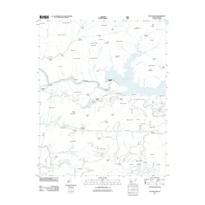
2011 Map of Fontana Dam
USGS Topo · Published 2011About this map
Fontana Lake dominates this mountain landscape, held back by the massive Fontana Dam along the Little Tennessee River. The area serves as a focal point for the mountain community of Fontana Village and the small settlement at Fairfax. Historically significant family markers are preserved in numerous burial grounds across the terrain, including Jenkins Cemetery, Payne Cemetery, and Welch Cove Cemetery. The geography is defined by deep coves and high ridges, such as Lewellyn Cove and the Cheoah Mountains. Industrial and recreational infrastructure appears through the Santeetlah Power House, Fontana Dock, and the Cable Gap Shelter along the high trails. This map captures the intersection of large-scale hydroelectric development and the enduring rural geography of Graham County, where old routes like Jack Shute Rd and Baymers Ferry Rd wind through the gaps.
Find a feature on this map
147 named features on this map. Tap any name to fly to it.
Don’t see what you’re looking for? This feature index may not catch every label — zoom into the map to look around manually.
Map Details
Editions of this 2011 Fontana Dam Map
This is the sole edition of this map. No revisions or reprints were ever made.
Other maps of this area

1886 · Knoxville
USGS Topo · 1:125,000

1892 · Knoxville
USGS Topo · 1:125,000

1894 · Knoxville
USGS Topo · 1:125,000

1895 · Knoxville
USGS Topo · 1:125,000

1901 · Knoxville
USGS Topo · 1:125,000

1933 · Bushnell
USGS Topo · 1:62,500

1935 · Robbinsville
USGS Topo · 1:24,000

1935 · Fontana
USGS Topo · 1:24,000

1935 · Calderwood
USGS Topo · 1:24,000

1935 · Santeetlah Creek
USGS Topo · 1:24,000