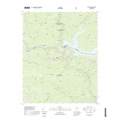
2019 Map of Fontana Dam
USGS Topo · Published 2019About this map
Fontana Dam stands as the central engineering landmark of this mountain landscape, spanning the Little Tennessee River to form the expansive Fontana Lake. The map details the transition from the Great Smoky Mountains National Park in the north to the Nantahala National Forest in the south, separated by the river's path and the county line between Swain and Graham. The Fontana Village settlement serves as a hub for the area's extensive trail network, including a prominent section of the Appalachian National Scenic Trail and the Fontana Loop. Scattered throughout the high ridges and deep coves are several family-named burial sites such as Welch Cove Cem, Payne Cem, and Cable Cove Cem, offering valuable data for genealogists tracing the legacy of families whose lands were largely absorbed into the national park and forest systems.
Find a feature on this map
151 named features on this map. Tap any name to fly to it.
Don’t see what you’re looking for? This feature index may not catch every label — zoom into the map to look around manually.
Map Details
Editions of this 2019 Fontana Dam Map
This is the sole edition of this map. No revisions or reprints were ever made.
Other maps of this area

1886 · Knoxville
USGS Topo · 1:125,000

1892 · Knoxville
USGS Topo · 1:125,000

1894 · Knoxville
USGS Topo · 1:125,000

1895 · Knoxville
USGS Topo · 1:125,000

1901 · Knoxville
USGS Topo · 1:125,000

1933 · Bushnell
USGS Topo · 1:62,500

1935 · Robbinsville
USGS Topo · 1:24,000

1935 · Fontana
USGS Topo · 1:24,000

1935 · Calderwood
USGS Topo · 1:24,000

1935 · Santeetlah Creek
USGS Topo · 1:24,000