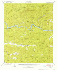
1940 Map of Fontana
USGS Topo · Published 1956About this map
The Great Smoky Mountains dominate the northern half of this landscape, where the proposed boundary for the national park meets the Nantahala National Forest. The Little Tennessee River carves through the center, feeding into Lake Cheoah and passing the Gaging Station. This era captures the region's industrial and transit network before major topographical changes, featuring the Fontana Copper Mine and the Santeetlah Power House. Local community life is centered around small rural institutions like Welch Cove Sch, Upper Yellow Creek Sch, and the Rock Spring Ch. The Appalachian Trail threads across the ridges, while the Southern railroad provides the primary valley transport. Family history is anchored in the Yellow Creek Cem and Cable Cove Cem, alongside settlements like Proctor and Fontana.
Find a feature on this map
107 named features on this map. Tap any name to fly to it.
Don’t see what you’re looking for? This feature index may not catch every label — zoom into the map to look around manually.
Map Details
Editions of this 1940 Fontana Map
2 editions found
Other maps of this area

1886 · Knoxville
USGS Topo · 1:125,000

1892 · Knoxville
USGS Topo · 1:125,000

1894 · Knoxville
USGS Topo · 1:125,000

1895 · Knoxville
USGS Topo · 1:125,000

1901 · Knoxville
USGS Topo · 1:125,000

1933 · Bushnell
USGS Topo · 1:62,500

1935 · Robbinsville
USGS Topo · 1:24,000

1935 · Fontana
USGS Topo · 1:24,000

1935 · Calderwood
USGS Topo · 1:24,000

1935 · Santeetlah Creek
USGS Topo · 1:24,000