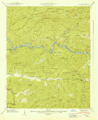
1941 Map of Fontana
USGS Topo · Published 1941About this map
Little Tennessee River flows through this 1941 landscape, a critical moment of transition before the hydroelectric development of the Tennessee Valley Authority fully reshaped the valley. The map documents the industrial and social infrastructure of Graham County just prior to the area's massive change, including the Fontana Copper Mine and the Santeetlah Power House along the banks of Cheoah Lake. Settlement patterns are visible through small mountain hamlets like Fairfax and Ritter, alongside a network of rural education sites such as New Fairfax Sch and Upper Yellow Creek Sch.
Find a feature on this map
131 named features on this map. Tap any name to fly to it.
Don’t see what you’re looking for? This feature index may not catch every label — zoom into the map to look around manually.
Map Details
Editions of this 1941 Fontana Map
This is the sole edition of this map. No revisions or reprints were ever made.
Other maps of this area

1886 · Knoxville
USGS Topo · 1:125,000

1892 · Knoxville
USGS Topo · 1:125,000

1894 · Knoxville
USGS Topo · 1:125,000

1895 · Knoxville
USGS Topo · 1:125,000

1901 · Knoxville
USGS Topo · 1:125,000

1933 · Bushnell
USGS Topo · 1:62,500

1935 · Robbinsville
USGS Topo · 1:24,000

1935 · Fontana
USGS Topo · 1:24,000

1935 · Calderwood
USGS Topo · 1:24,000

1935 · Santeetlah Creek
USGS Topo · 1:24,000