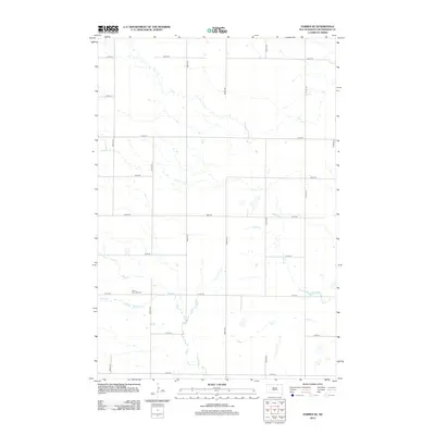
2012 Map of Forbes SE
USGS Topo · Published 2012About this map
Saint Hyacinth Cem is the primary cultural landmark in this rural landscape of McPherson County, located just north of Willow Cr. The terrain is defined by a rigorous grid of section lines, with north-south routes like 366th Ave and 370th Ave intersecting east-west roads from 105th St down to 113th St. This 2012 survey illustrates the enduring agricultural structure of the High Plains, where the drainage patterns of Dry Run cut across the geometric precision of the township and range survey system. The absence of established town centers highlights the area's character as a network of farmsteads and open fields, where small family or parish landmarks like the local cemetery provide the essential points of orientation for researchers and genealogists.
Find a feature on this map
20 named features on this map. Tap any name to fly to it.
Don’t see what you’re looking for? This feature index may not catch every label — zoom into the map to look around manually.
Map Details
Editions of this 2012 Forbes SE Map
This is the sole edition of this map. No revisions or reprints were ever made.
Other maps of this area

1894 · Ellendale
USGS Topo · 1:62,500

1899 · Ellendale
USGS Topo · 1:125,000

1954 · Aberdeen
USGS Topo · 1:250,000

1956 · Aberdeen
USGS Topo · 1:250,000
1968 · Frederick NW
USGS Topo · 1:24,000

1968 · Forbes
USGS Topo · 1:24,000

1968 · Forbes SE
USGS Topo · 1:24,000
1968 · Forbes NW
USGS Topo · 1:24,000

1968 · Forbes SW
USGS Topo · 1:24,000
1968 · Frederick SW
USGS Topo · 1:24,000