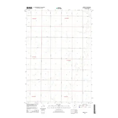
2015 Map of Forbes SE
USGS Topo · Published 2015About this map
Saint Hyacinth Cem is situated near the crossing of 367th Ave and 111th St, serving as a primary landmark in this rural stretch of McPherson County. The landscape is defined by the ephemeral courses of Dry Run and Willow Cr, which drain the prairie terrain. This 2015 survey illustrates a highly organized grid of section lines and county roads, including 371st Ave and 105th St, that partition the agricultural land into precise townships. The layout of these corridors demonstrates the enduring legacy of the Public Land Survey System in the Great Plains, where transportation and land ownership are intrinsically linked to the township and range divisions such as t127n r66w and t128n r67w.
Find a feature on this map
24 named features on this map. Tap any name to fly to it.
Don’t see what you’re looking for? This feature index may not catch every label — zoom into the map to look around manually.
Map Details
Editions of this 2015 Forbes SE Map
This is the sole edition of this map. No revisions or reprints were ever made.
Other maps of this area

1894 · Ellendale
USGS Topo · 1:62,500

1899 · Ellendale
USGS Topo · 1:125,000

1954 · Aberdeen
USGS Topo · 1:250,000

1956 · Aberdeen
USGS Topo · 1:250,000
1968 · Frederick NW
USGS Topo · 1:24,000

1968 · Forbes
USGS Topo · 1:24,000

1968 · Forbes SE
USGS Topo · 1:24,000
1968 · Forbes NW
USGS Topo · 1:24,000

1968 · Forbes SW
USGS Topo · 1:24,000
1968 · Frederick SW
USGS Topo · 1:24,000