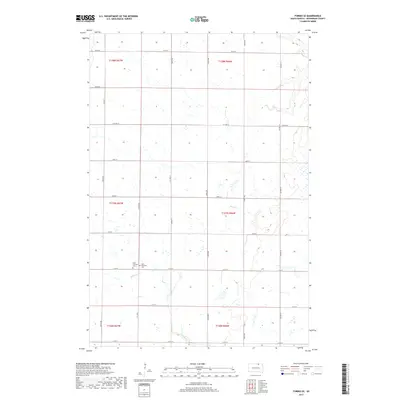
2017 Map of Forbes SE
USGS Topo · Published 2017About this map
Saint Hyacinth Cem and Saint Hyacinth Cem 2 stand as central landmarks in this rural landscape of McPherson County, reflecting the area's pioneer heritage and community lineage. The terrain is defined by the ephemeral courses of Willow Cr and the appropriately named Dry Run, which navigate a high plateau patterned with numerous small wetlands and depressions. A strict orthogonal grid of section lines and county roads, including Cty Hwy 8 and Cty Hwy 21, organizes the agricultural interior. This 2017 survey illustrates the enduring nature of the Great Plains' rural layout, where historical cemeteries remains anchored to the landscape long after many surrounding homesteads have consolidated into large-scale farming operations.
Find a feature on this map
28 named features on this map. Tap any name to fly to it.
Don’t see what you’re looking for? This feature index may not catch every label — zoom into the map to look around manually.
Map Details
Editions of this 2017 Forbes SE Map
This is the sole edition of this map. No revisions or reprints were ever made.
Other maps of this area

1894 · Ellendale
USGS Topo · 1:62,500

1899 · Ellendale
USGS Topo · 1:125,000

1954 · Aberdeen
USGS Topo · 1:250,000

1956 · Aberdeen
USGS Topo · 1:250,000
1968 · Frederick NW
USGS Topo · 1:24,000

1968 · Forbes
USGS Topo · 1:24,000

1968 · Forbes SE
USGS Topo · 1:24,000
1968 · Forbes NW
USGS Topo · 1:24,000

1968 · Forbes SW
USGS Topo · 1:24,000
1968 · Frederick SW
USGS Topo · 1:24,000