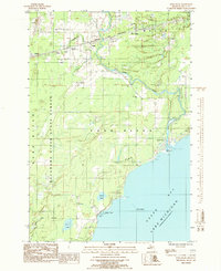
1985 Map of Ford River
USGS Topo · Published 1985About this map
The Ford River winds toward the waters of Green Bay in this 1980s provisional study of Delta County. This coastal landscape is defined by the heavy timber of the Escanaba River State Forest and a series of small, dispersed settlements including Narenta, Hyde, and Pine Ridge. The Chicago and North Western rail corridor provides the primary infrastructure link across the northern interior, connecting these rural outposts. Local life is anchored by community landmarks such as the West Ford River Cem, Ford River Sch, and the Highland Country Club. Near the shoreline, the map identifies small lakes and seasonal landmarks like North Lake and Island View, alongside modern communication infrastructure including Radio Towers (WBDN).
Find a feature on this map
31 named features on this map. Tap any name to fly to it.
Don’t see what you’re looking for? This feature index may not catch every label — zoom into the map to look around manually.
Map Details
Editions of this 1985 Ford River Map
This is the sole edition of this map. No revisions or reprints were ever made.
Other maps of this area

1932 · Gladstone SE
USGS Topo · 1:31,680

1932 · Bark River NE
USGS Topo · 1:31,680

1932 · Whitney SE
USGS Topo · 1:31,680

1932 · Gladstone SW
USGS Topo · 1:31,680

1954 · Escanaba
USGS Topo · 1:250,000

1957 · Escanaba
USGS Topo · 1:250,000

1958 · Escanaba
USGS Topo · 1:250,000

1958 · Gladstone
USGS Topo · 1:62,500

1958 · Escanaba
USGS Topo · 1:62,500

1963 · Bark River
USGS Topo · 1:62,500
Featured Places
- Ford River, Ford River Township
- Ford River Township, MI
- Bark River Township, MI
- Narenta, Ford River Township
- Island View, Ford River Township