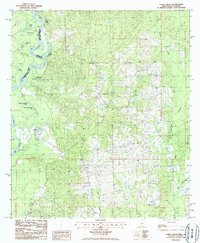
1986 Map of Fords Creek
USGS Topo · Published 1986About this map
The Pearl River snakes along the border between Washington Parish and Pearl River County, defining the boundary between Mississippi and Louisiana. This 1980s landscape is dominated by the dense network of oxbow lakes and wetlands adjacent to the river, including Aaron Lake, Hunt Lake, Road Lake, and Horseshoe Lake. The presence of Hunt Bluff offers a rare point of elevation overlooking the floodplain, while further inland, the terrain is carved by Fords Creek and Mill Creek. Small, isolated symbols for School and various Cem locations point to the rural social fabric of the era, where family-named landmarks like John Henry Lake and Harry Lake suggest a long history of local land use along the river's edge.
Find a feature on this map
24 named features on this map. Tap any name to fly to it.
Don’t see what you’re looking for? This feature index may not catch every label — zoom into the map to look around manually.
Map Details
Editions of this 1986 Fords Creek Map
This is the sole edition of this map. No revisions or reprints were ever made.
Other maps of this area

1949 · Bogalusa East
USGS Topo · 1:31,680

1949 · Angie
USGS Topo · 1:31,680

1953 · Hattiesburg
USGS Topo · 1:250,000

1953 · Mobile
USGS Topo · 1:250,000

1957 · Mobile
USGS Topo · 1:250,000

1958 · Hattiesburg
USGS Topo · 1:250,000

1959 · Bogalusa
USGS Topo · 1:62,500

1959 · Poplarville
USGS Topo · 1:62,500

1960 · Mobile
USGS Topo · 1:250,000

1963 · Mobile
USGS Topo · 1:250,000