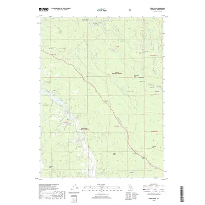
2018 Map of Forest Glen
USGS Topo · Published 2018About this map
Ruth and Forest Glen anchor this survey of the mountainous interior where the Trinity National Forest meets the Six Rivers National Forest. The landscape is defined by the steep drainage basins of the Mad River and the S Fork Trinity River, with numerous small flats providing the few level sites for habitation. The presence of the Silver Creek Ranch Airport near Silver Flat and Bee Tree Flat highlights the reliance on small-scale aviation in these remote reaches. The Mad River Rd follows the winding river course, connecting local settlements and providing access to recreation at Ruth Lake. Strategic high points like South Fork Mtn and Pickett Peak dominate the topography, with the Horse Ridge Lookout standing as a sentinel over the surrounding timberlands and the Johnson Glades.
Find a feature on this map
88 named features on this map. Tap any name to fly to it.
Don’t see what you’re looking for? This feature index may not catch every label — zoom into the map to look around manually.
Map Details
Editions of this 2018 Forest Glen Map
This is the sole edition of this map. No revisions or reprints were ever made.
Other maps of this area

1918 · Anada
USGS Topo · 1:62,500

1921 · Hoaglin
USGS Topo · 1:62,500

1922 · Island Mountain
USGS Topo · 1:62,500

1931 · Hoaglin
USGS Topo · 1:96,000

1935 · Hoaglin
USGS Topo · 1:125,000

1953 · Blackrock Mtn
USGS Topo · 1:62,500

1954 · Pickett Peak
USGS Topo · 1:62,500

1954 · Dubakella Mtn
USGS Topo · 1:62,500

1954 · Blackrock Mtn
USGS Topo · 1:62,500
1955 · Kettenpom
USGS Topo · 1:62,500