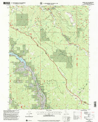
1997 Map of Forest Glen
USGS Topo · Published 2001About this map
The South Fork Trinity River carves through the heart of this landscape, serving as a primary corridor for the Trinity National Forest in the late 1990s. At Forest Glen, the presence of the Forest Glen Ranger Station and a solitary Grave near Hell Gate point to the area's long-standing role as a crossroads for forestry and early mountain travel. The terrain is marked by numerous named flats, such as Taylor Flat and Double Cabin Flat, which represent rare level ground within the steep drainage basins.
Find a feature on this map
83 named features on this map. Tap any name to fly to it.
Don’t see what you’re looking for? This feature index may not catch every label — zoom into the map to look around manually.
Map Details
Editions of this 1997 Forest Glen Map
This is the sole edition of this map. No revisions or reprints were ever made.
Other maps of this area

1918 · Anada
USGS Topo · 1:62,500

1921 · Hoaglin
USGS Topo · 1:62,500

1922 · Island Mountain
USGS Topo · 1:62,500

1931 · Hoaglin
USGS Topo · 1:96,000

1935 · Hoaglin
USGS Topo · 1:125,000

1953 · Blackrock Mtn
USGS Topo · 1:62,500

1954 · Pickett Peak
USGS Topo · 1:62,500

1954 · Dubakella Mtn
USGS Topo · 1:62,500

1954 · Blackrock Mtn
USGS Topo · 1:62,500
1955 · Kettenpom
USGS Topo · 1:62,500