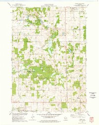
1975 Map of Forest
USGS Topo · Published 1978About this map
The village of Clear Lake and its surrounding wetlands define this mid-1970s landscape on the border of Polk and St. Croix Counties. The Chicago and North Western railroad cuts diagonally across the terrain, passing through the northern portion of the quadrangle near a local Townhall and several Gravel Pits. Significant conservation efforts are evident in the sprawling Cylon State Public Hunting Grounds and the National Waterfowl Production Area near Long Lake, reflecting the region's commitment to wildlife management and public land use.
Find a feature on this map
30 named features on this map. Tap any name to fly to it.
Don’t see what you’re looking for? This feature index may not catch every label — zoom into the map to look around manually.
Map Details
Editions of this 1975 Forest Map
This is the sole edition of this map. No revisions or reprints were ever made.
Other maps of this area

1948 · Downing
USGS Topo · 1:62,500

1950 · Downing
USGS Topo · 1:62,500

1950 · Deer Park
USGS Topo · 1:62,500

1950 · Balsam Lake
USGS Topo · 1:62,500

1950 · Turtle Lake
USGS Topo · 1:62,500

1952 · Turtle Lake
USGS Topo · 1:62,500

1953 · Stillwater
USGS Topo · 1:250,000

1955 · Stillwater
USGS Topo · 1:250,000

1958 · Stillwater
USGS Topo · 1:250,000

1965 · Stillwater
USGS Topo · 1:250,000