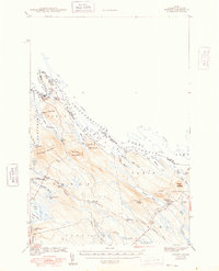
1942 Map of Forest
USGS Topo · Published 1948About this map
The St Croix River defines the international boundary in this 1940s survey of eastern Maine, where the waters of the Chiputneticook Lakes and Spednik Lake separate Washington County from New Brunswick. The settlement of Forest City sits at the northern narrow, supported by the Forest City Landing and the Maine Central railroad line that cuts through the southern interior.
Find a feature on this map
56 named features on this map. Tap any name to fly to it.
Don’t see what you’re looking for? This feature index may not catch every label — zoom into the map to look around manually.
Map Details
Editions of this 1942 Forest Map
2 editions found

Other maps of this area

1930 · Vanceboro
USGS Topo · 1:48,000

1933 · Vanceboro
USGS Topo · 1:62,500

1940 · Danforth
USGS Topo · 1:62,500

1940 · Amity
USGS Topo · 1:62,500

1940 · Waite
USGS Topo · 1:62,500

1940 · Forest
USGS Topo · 1:62,500

1940 · Kellyland
USGS Topo · 1:62,500

1941 · Danforth
USGS Topo · 1:62,500

1941 · Amity
USGS Topo · 1:62,500

1941 · Scraggly Lake
USGS Topo · 1:62,500