
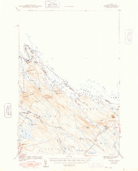
1942 Map of Forest
USGS Topo · Published 1942About this map
The Canada-United States border follows the deep waters of the Chiputneticook Lakes and Spednik Lake in this 1940s survey of eastern Maine. The landscape is defined by its international water boundaries and the vital rail lines that connect this remote timber country to the larger world. The Maine Central and Canadian Pacific railroads traverse the southern portion of the quadrangle, serving small outposts like Forest and Lambert Lake. Local commerce and movement are dictated by the terrain, with Forest City Landing and Forest City anchoring the north near the St Croix River. Topographical landmarks such as Tomah Mountain and Vance Mountain rise above the complex network of brooks and streams, while a Fire Tower on Pirate Hill stands watch over the surrounding forest and the small clearing at Todds Farm.
Find a feature on this map
57 named features on this map. Tap any name to fly to it.
Don’t see what you’re looking for? This feature index may not catch every label — zoom into the map to look around manually.
Map Details
Editions of this 1942 Forest Map
2 editions found
Other maps of this area

1930 · Vanceboro
USGS Topo · 1:48,000

1933 · Vanceboro
USGS Topo · 1:62,500

1940 · Danforth
USGS Topo · 1:62,500

1940 · Amity
USGS Topo · 1:62,500

1940 · Waite
USGS Topo · 1:62,500

1940 · Forest
USGS Topo · 1:62,500

1940 · Kellyland
USGS Topo · 1:62,500

1941 · Danforth
USGS Topo · 1:62,500

1941 · Amity
USGS Topo · 1:62,500

1941 · Scraggly Lake
USGS Topo · 1:62,500