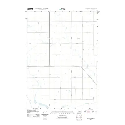
2012 Map of Forestburg SW
USGS Topo · Published 2012About this map
Sand Cr meanders through this portion of Sanborn County, illustrating the intensive drainage management common in South Dakota's agricultural heartland. The landscape is defined by an orderly grid of section roads, including 401st Ave and 228th St, which connect dispersed rural homesteads. Significant engineering is evident in the presence of County Ditch Number 8, County Ditch Number 21, and County Ditch Number 14, which direct water across the prairie to support local farming. For those tracing family history in the area, the map identifies two key burial sites: Bethany-Silver Creek Cem and Silver Creek Cem. At the southern edge, the terrain transitions toward Long Lake, providing a natural contrast to the surrounding rectilinear fields and drainage channels.
Find a feature on this map
20 named features on this map. Tap any name to fly to it.
Don’t see what you’re looking for? This feature index may not catch every label — zoom into the map to look around manually.
Map Details
Editions of this 2012 Forestburg SW Map
This is the sole edition of this map. No revisions or reprints were ever made.
Other maps of this area

1898 · Huron
USGS Topo · 1:125,000

1899 · Mitchell
USGS Topo · 1:125,000

1953 · Huron
USGS Topo · 1:250,000

1954 · Huron
USGS Topo · 1:250,000

1955 · Mitchell
USGS Topo · 1:250,000

1957 · Forestburg NE
USGS Topo · 1:24,000
1957 · Forestburg
USGS Topo · 1:24,000

1957 · Letcher NE
USGS Topo · 1:24,000

1958 · Forestburg NW
USGS Topo · 1:24,000

1959 · Mitchell
USGS Topo · 1:250,000
Featured Places
- Warren Township, SD
- Jackson Township, SD
- Twin Lake Township, SD
- Woonsocket Township, SD
- Logan Township, SD