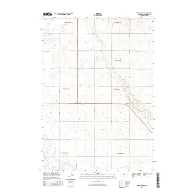
2015 Map of Forestburg SW
USGS Topo · Published 2015About this map
Sanborn County agriculture and drainage systems define this 2015 landscape, where an intricate network of man-made waterways like County Ditch Number 8 and County Ditch Number 21 intersect the natural course of Sand Cr. This section of South Dakota is marked by the rectilinear grid of rural roads, including 230th St and 400th Ave, which organize the farmsteads and fields of the prairie. Local heritage is preserved at two sites of interment, Bethany-Silver Creek Cem and Silver Creek Cem, which serve as quiet landmarks for genealogists tracing families in the area. In the southern reach of the survey, the terrain yields to the waters of Long Lake, showing the characteristic wetland depressions that dot this region.
Find a feature on this map
27 named features on this map. Tap any name to fly to it.
Don’t see what you’re looking for? This feature index may not catch every label — zoom into the map to look around manually.
Map Details
Editions of this 2015 Forestburg SW Map
This is the sole edition of this map. No revisions or reprints were ever made.
Other maps of this area

1898 · Huron
USGS Topo · 1:125,000

1899 · Mitchell
USGS Topo · 1:125,000

1953 · Huron
USGS Topo · 1:250,000

1954 · Huron
USGS Topo · 1:250,000

1955 · Mitchell
USGS Topo · 1:250,000

1957 · Forestburg NE
USGS Topo · 1:24,000
1957 · Forestburg
USGS Topo · 1:24,000

1957 · Letcher NE
USGS Topo · 1:24,000

1958 · Forestburg NW
USGS Topo · 1:24,000

1959 · Mitchell
USGS Topo · 1:250,000
Featured Places
- Warren Township, SD
- Jackson Township, SD
- Twin Lake Township, SD
- Woonsocket Township, SD
- Logan Township, SD