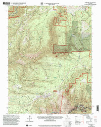
2000 Map of Foresthill
USGS Topo · Published 2003About this map
Foresthill and the neighboring settlement of Iowa Hill anchor this detailed study of Placer County’s gold country at the turn of the millennium. The landscape is defined by the deep incisions of the North Fork American River and the Middle Fork American River, with the Foresthill Divide Road running the ridge between them. The map documents a dense concentration of mining heritage, from the historic Yankee Jims area to active or inactive sites like the Mayflower Mine and Paragon Mine.
Find a feature on this map
118 named features on this map. Tap any name to fly to it.
Don’t see what you’re looking for? This feature index may not catch every label — zoom into the map to look around manually.
Map Details
Editions of this 2000 Foresthill Map
This is the sole edition of this map. No revisions or reprints were ever made.
Other maps of this area

1891 · Colfax
USGS Topo · 1:125,000

1891 · Placerville
USGS Topo · 1:125,000

1892 · Placerville
USGS Topo · 1:125,000

1892 · Colfax
USGS Topo · 1:125,000

1893 · Placerville
USGS Topo · 1:125,000

1894 · Colfax
USGS Topo · 1:125,000

1898 · Colfax
USGS Topo · 1:125,000

1900 · Colfax
USGS Topo · 1:125,000

1902 · Colfax
USGS Topo · 1:125,000

1938 · Colfax
USGS Topo · 1:125,000