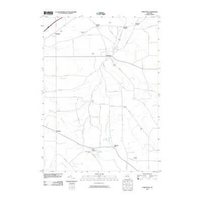
2010 Map of Forestville
USGS Topo · Published 2010About this map
Forestville serves as the central hub of this Chautauqua County landscape, where the waters of Walnut Creek and Beaver Creek wind through a region defined by family farms and local viticulture. Agricultural heritage is prominent, anchored by Merritt Estate Winery and several named operations like Falcone Farms and Killdeer Farms. The map reveals a high density of rural crossroads and burial grounds, such as Abbey Cemetery, Pioneer Cemetery, and the Arkwright Summit Cemetery near Arkwright.
Find a feature on this map
68 named features on this map. Tap any name to fly to it.
Don’t see what you’re looking for? This feature index may not catch every label — zoom into the map to look around manually.
Map Details
Editions of this 2010 Forestville Map
This is the sole edition of this map. No revisions or reprints were ever made.
Other maps of this area

1899 · Silver Creek
USGS Topo · 1:62,500

1900 · Dunkirk
USGS Topo · 1:62,500

1900 · Cherry Creek
USGS Topo · 1:62,500

1941 · Cherry Creek
USGS Topo · 1:62,500

1943 · Dunkirk
USGS Topo · 1:62,500

1943 · Silver Creek
USGS Topo · 1:24,000

1944 · Farnham
USGS Topo · 1:31,680

1944 · Silver Creek
USGS Topo · 1:31,680
1954 · Hamlet
USGS Topo · 1:24,000

1954 · Forestville
USGS Topo · 1:24,000