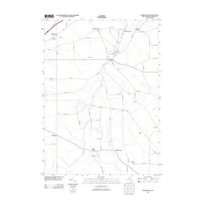
2013 Map of Forestville
USGS Topo · Published 2013About this map
Walnut Creek and its many tributaries define the landscape of Chautauqua County as they flow toward Lake Erie, carving a network of valleys that historically dictated settlement patterns. The village of Forestville stands as the primary hub of this 2013 survey, surrounded by established family farms such as Falcone Farms and Killdeer Farms. The area is notably dense with burial grounds, ranging from Sheridan Center Cemetery in the north to Arkwright Summit Cemetery in the south, suggesting a long-standing residency of local families. These cemeteries, alongside small junctions like Keaches Corners and Dennison Corners, offer significant touchpoints for genealogists tracing ancestral homesteads in western New York. The southern reaches of the map transitions into higher ground near Pope Hill, where the headwaters of the West Branch Conewango Creek emerge from the wetlands around West Mud Lake and Black Pond.
Find a feature on this map
83 named features on this map. Tap any name to fly to it.
Don’t see what you’re looking for? This feature index may not catch every label — zoom into the map to look around manually.
Map Details
Editions of this 2013 Forestville Map
This is the sole edition of this map. No revisions or reprints were ever made.
Other maps of this area

1899 · Silver Creek
USGS Topo · 1:62,500

1900 · Dunkirk
USGS Topo · 1:62,500

1900 · Cherry Creek
USGS Topo · 1:62,500

1941 · Cherry Creek
USGS Topo · 1:62,500

1943 · Dunkirk
USGS Topo · 1:62,500

1943 · Silver Creek
USGS Topo · 1:24,000

1944 · Farnham
USGS Topo · 1:31,680

1944 · Silver Creek
USGS Topo · 1:31,680
1954 · Hamlet
USGS Topo · 1:24,000

1954 · Forestville
USGS Topo · 1:24,000