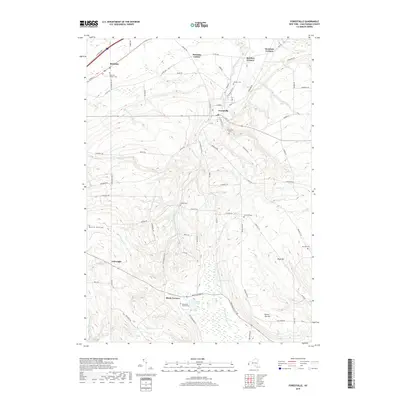
2019 Map of Forestville
USGS Topo · Published 2019About this map
Forestville and Sheridan anchor this Chautauqua County landscape, where the terrain shifts from the coastal plains near Lake Erie into the upland ridges of the Allegheny Plateau. The village of Forestville sits at a geographic crossroads along Walnut Cr, surrounded by a network of family-named corners such as Keaches Corners, Hawkins Corner, and Dennison Corners. These small nodes reflect the agricultural history of the region, where crossroads served as local gathering points for the surrounding farmsteads.
Find a feature on this map
79 named features on this map. Tap any name to fly to it.
Don’t see what you’re looking for? This feature index may not catch every label — zoom into the map to look around manually.
Map Details
Editions of this 2019 Forestville Map
This is the sole edition of this map. No revisions or reprints were ever made.
Other maps of this area

1899 · Silver Creek
USGS Topo · 1:62,500

1900 · Dunkirk
USGS Topo · 1:62,500

1900 · Cherry Creek
USGS Topo · 1:62,500

1941 · Cherry Creek
USGS Topo · 1:62,500

1943 · Dunkirk
USGS Topo · 1:62,500

1943 · Silver Creek
USGS Topo · 1:24,000

1944 · Farnham
USGS Topo · 1:31,680

1944 · Silver Creek
USGS Topo · 1:31,680
1954 · Hamlet
USGS Topo · 1:24,000

1954 · Forestville
USGS Topo · 1:24,000