2023 Map of Forestville
USGS Topo · Published 2023About this map
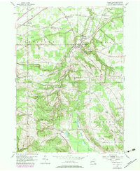
Forestville sits at the heart of this landscape, where the terrain begins to transition from the coastal plains of Lake Erie into the upland plateaus of Chautauqua County. The topography is defined by the deep incisions of Walnut Creek and Beaver Creek, creating a complex network of ridges and valleys that directed the layout of early roads like Co Touring Rte 85 and Co Rd 320. Significant for genealogists, the map preserves the locations of several burial grounds, including the Sheridan Pioneer Cem near the northern settlement of Sheridan and the Arkwright Summit Cem further south.
Find a feature on this map
81 named features on this map. Tap any name to fly to it.
Don’t see what you’re looking for? This feature index may not catch every label — zoom into the map to look around manually.
Map Details
Editions of this 2023 Forestville Map
This is the sole edition of this map. No revisions or reprints were ever made.