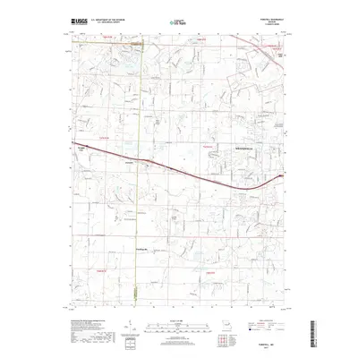
2017 Map of Foristell
USGS Topo · Published 2017About this map
Wentzville and its surrounding agricultural and residential transition define this portion of Saint Charles and Warren Counties during the late 2010s. The landscape is marked by the central corridor of Interstate 70, which connects the communities of Wright City, Foristell, and Wentzville. Rural traditions remain visible in the placement of the Metcalf Cem, Oak Grove Cem, and Pauldingville Cem, which offer significant data points for genealogical research in the area. Smaller aviation sites like Ahlers Acres Airport and Woodliff Airpark are tucked between expanding residential developments and managed water bodies such as Incline Village Lake and Number 123 Reservoir. The drainage patterns of Peruque Cr and McCoy Cr weave through the region, illustrating the hydrologic network that supported early settlements like Pauldingville and Flint Hill before the modern era of highway-driven suburban growth.
Find a feature on this map
168 named features on this map. Tap any name to fly to it.
Don’t see what you’re looking for? This feature index may not catch every label — zoom into the map to look around manually.
Map Details
Editions of this 2017 Foristell Map
This is the sole edition of this map. No revisions or reprints were ever made.
Other maps of this area

1890 · Hermann
USGS Topo · 1:125,000

1903 · O'Fallon
USGS Topo · 1:125,000

1941 · Troy
USGS Topo · 1:62,500

1943 · Warrenton
USGS Topo · 1:62,500

1945 · Troy
USGS Topo · 1:62,500

1945 · Warrenton
USGS Topo · 1:62,500

1948 · Washington
USGS Topo · 1:62,500

1948 · Augusta
USGS Topo · 1:62,500

1949 · Saint Louis
USGS Topo · 1:250,000
1949 · Washington
USGS Topo · 1:62,500