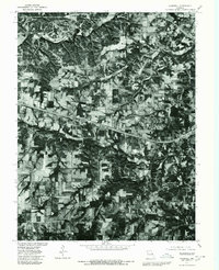
1979 Map of Foristell
USGS Topo · Published 1980About this map
Foristell serves as the central point of interest on this 1979 orthophotoquad, which uses aerial photography to document the landscape of western St. Charles and eastern Warren counties. The town is situated along a major transportation corridor that cuts across the terrain, illustrating the relationship between infrastructure and the undulating Missouri countryside. This specific edition provides an unfiltered visual record of land use, where the wooded valleys and cleared agricultural fields are clearly delineated. The winding course of Peruque Creek flows through the southern portion of the sheet, while the Fifth Principal Meridian serves as the primary longitudinal baseline for the regional land survey. Because this is an orthophotograph rather than a standard topographic line map, it offers researchers a distinct look at actual vegetation cover and farmstead layouts at the close of the 1970s.
Find a feature on this map
3 named features on this map. Tap any name to fly to it.
Don’t see what you’re looking for? This feature index may not catch every label — zoom into the map to look around manually.
Map Details
Editions of this 1979 Foristell Map
This is the sole edition of this map. No revisions or reprints were ever made.
Other maps of this area

1890 · Hermann
USGS Topo · 1:125,000

1903 · O'Fallon
USGS Topo · 1:125,000

1941 · Troy
USGS Topo · 1:62,500

1943 · Warrenton
USGS Topo · 1:62,500

1945 · Troy
USGS Topo · 1:62,500

1945 · Warrenton
USGS Topo · 1:62,500

1948 · Washington
USGS Topo · 1:62,500

1948 · Augusta
USGS Topo · 1:62,500

1949 · Saint Louis
USGS Topo · 1:250,000
1949 · Washington
USGS Topo · 1:62,500