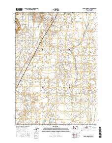
2017 Map of Forked Horn Butte
USGS Topo · Published 2017About this map
Redmond and the adjacent high desert landscape are defined by a complex network of irrigation infrastructure and volcanic topography. This modern survey illustrates how water management has transformed the arid terrain of Deschutes County, with the Pilot Butte Canal, North Unit Main Canal, and Lateral C winding through the countryside to support local agriculture and development. The volcanic heritage of the region is anchored by the prominent Forked Horn Butte in the northwest, while the Deschutes River cuts a deep path along the eastern edge of the quadrangle. Significant local landmarks include Roberts Field and the Redmond Cem, providing essential points of reference for genealogists and local historians. The transition from established residential grids in the north to newer developments like Pronghorn in the south reflects the ongoing expansion of the High Desert region.
Find a feature on this map
55 named features on this map. Tap any name to fly to it.
Don’t see what you’re looking for? This feature index may not catch every label — zoom into the map to look around manually.
Map Details
Editions of this 2017 Forked Horn Butte Map
This is the sole edition of this map. No revisions or reprints were ever made.
Other maps of this area

1926 · Bend
USGS Topo · 1:125,000

1929 · Bend
USGS Topo · 1:125,000

1955 · Bend
USGS Topo · 1:250,000

1957 · Bend
USGS Topo · 1:250,000

1958 · Bend
USGS Topo · 1:250,000

1961 · Redmond
USGS Topo · 1:24,000

1962 · Forked Horn Butte
USGS Topo · 1:24,000
1962 · Bend
USGS Topo · 1:24,000

1962 · Oneil
USGS Topo · 1:24,000
1962 · Bend Airport
USGS Topo · 1:24,000