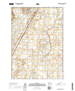
2020 Map of Forked Horn Butte
USGS Topo · Published 2020About this map
Redmond and the adjacent landscape in Deschutes County are documented here as of 2020, showing a region defined by its volcanic geology and extensive irrigation network. The distinctive profile of Forked-Horn-Butte stands near the northern edge, while the agricultural and residential growth of the area is illustrated through the course of the Pilot Butte Canal and the North Unit Main Canal. These waterways represent the vital infrastructure required to sustain the high desert community. To the east, the sprawling development of Pronghorn and the municipal importance of Roberts Field indicate the shift from traditional ranching and farming toward contemporary recreational and transportation land use. Genealogy researchers will find the Redmond Cem clearly marked, along with a grid of family-named roads such as Joe Neil Rd and Harry Rd that trace the historical divisions of the land.
Find a feature on this map
57 named features on this map. Tap any name to fly to it.
Don’t see what you’re looking for? This feature index may not catch every label — zoom into the map to look around manually.
Map Details
Editions of this 2020 Forked Horn Butte Map
This is the sole edition of this map. No revisions or reprints were ever made.
Other maps of this area

1926 · Bend
USGS Topo · 1:125,000

1929 · Bend
USGS Topo · 1:125,000

1955 · Bend
USGS Topo · 1:250,000

1957 · Bend
USGS Topo · 1:250,000

1958 · Bend
USGS Topo · 1:250,000

1961 · Redmond
USGS Topo · 1:24,000

1962 · Forked Horn Butte
USGS Topo · 1:24,000
1962 · Bend
USGS Topo · 1:24,000

1962 · Oneil
USGS Topo · 1:24,000
1962 · Bend Airport
USGS Topo · 1:24,000