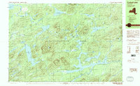
1989 Map of Forked Lake
USGS Topo · Published 1989About this map
Adirondack Park dominates this interior landscape of Hamilton County, showcasing a complex network of waterways and glacial peaks in the late 1980s. The terrain is defined by significant elevations such as Antediluvian Mountain, Salmon Lake Mountain, and Owls Head Mountain, which overlook a dense collection of ponds and lakes. Water bodies like Salmon Lake, Lake Lila, and the specialized North Pond Flowgrounds suggest a region managed for wilderness preservation and low-impact recreation.
Find a feature on this map
62 named features on this map. Tap any name to fly to it.
Don’t see what you’re looking for? This feature index may not catch every label — zoom into the map to look around manually.
Map Details
Editions of this 1989 Forked Lake Map
2 editions found
Other maps of this area

1903 · Big Moose
USGS Topo · 1:62,500

1903 · Raquette Lake
USGS Topo · 1:62,500

1903 · Blue Mountain
USGS Topo · 1:62,500

1904 · Long Lake
USGS Topo · 1:62,500

1907 · Tupper Lake
USGS Topo · 1:62,500

1919 · Cranberry Lake
USGS Topo · 1:62,500

1921 · Cranberry Lake
USGS Topo · 1:62,500

1931 · Cranberry Lake
USGS Topo · 1:62,500

1948 · Ogdensburg
USGS Topo · 1:250,000

1950 · Utica
USGS Topo · 1:250,000