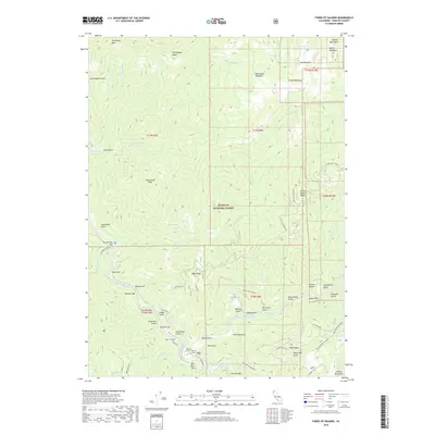
2018 Map of Forks of Salmon
USGS Topo · Published 2018About this map
The Forks of Salmon marks the confluence where the North Fork Salmon River and South Fork join, creating a landscape defined by riverside settlements and alluvial benches. These river flats, including Brazille Flat, Nordheimer Flat, and Shumway Flat, historically supported the region's mining and ranching activities. The influence of early Chinese mining is preserved in names like Fong Wah Bar and Fong Wah Gulch, while other riverside sites such as Knudsen Bar and Glasgow Bar indicate the locations of gold-era placer workings along the Salmon River.
Find a feature on this map
85 named features on this map. Tap any name to fly to it.
Don’t see what you’re looking for? This feature index may not catch every label — zoom into the map to look around manually.
Map Details
Editions of this 2018 Forks of Salmon Map
This is the sole edition of this map. No revisions or reprints were ever made.
Other maps of this area

1948 · Weed
USGS Topo · 1:250,000

1950 · Weed
USGS Topo · 1:250,000

1955 · Salmon Mtn
USGS Topo · 1:62,500

1955 · Cecilville
USGS Topo · 1:62,500

1955 · Sawyers Bar
USGS Topo · 1:62,500

1955 · Forks of Salmon
USGS Topo · 1:62,500

1958 · Weed
USGS Topo · 1:250,000

1963 · Weed
USGS Topo · 1:250,000

1974 · Orleans Mtn.
USGS Topo · 1:24,000
1977 · English Peak
USGS Topo · 1:24,000