
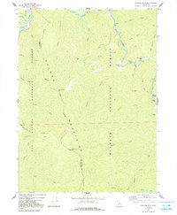
1974 Map of Orleans Mtn.
USGS Topo · Published 1977About this map
The Salmon Mountains define this landscape, where the confluence of the Klamath River and the Salmon River creates a rugged interior of river bars and steep ridges. In the early 1970s, this area remained largely wild, dominated by the Klamath National Forest and Six Rivers National Forest. The map documents a history of remote mining operations along the river corridors, including the Indian Bottom Mine and Morehouse Mine. High-altitude landmarks like the Orleans Mtn Lookout and a nearby Antenna atop Ridge served as vital communication and observation points for the surrounding wilderness. Historic river features like Three Dollar Bar and Murderers Bar reflect the gold-seeking heritage of the canyon floors, while a series of jeep trails provide the only mechanized access through the steep terrain between Somes Mtn and the Siskiyou Co and Humboldt Co line.
Find a feature on this map
42 named features on this map. Tap any name to fly to it.
Don’t see what you’re looking for? This feature index may not catch every label — zoom into the map to look around manually.
Map Details
Editions of this 1974 Orleans Mtn. Map
2 editions found
Other maps of this area

1925 · Hoopa
USGS Topo · 1:125,000

1948 · Weed
USGS Topo · 1:250,000

1950 · Weed
USGS Topo · 1:250,000

1952 · Hoopa
USGS Topo · 1:62,500

1952 · Orleans
USGS Topo · 1:62,500

1955 · Salmon Mtn
USGS Topo · 1:62,500

1955 · Forks of Salmon
USGS Topo · 1:62,500

1958 · Weed
USGS Topo · 1:250,000

1963 · Weed
USGS Topo · 1:250,000
1974 · Bark Shanty Gulch
USGS Topo · 1:24,000