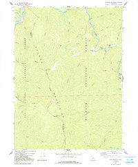
1974 Map of Orleans Mtn.
USGS Topo · Published 1991About this map
The Salmon River and Klamath River converge in this mid-1970s topography, revealing a landscape defined by gold mining history and rugged river terrace settlements. The eastern corridor along the Salmon River is particularly rich in mining heritage, showing the Indian Bottom Mine, Morehouse Mine, and the curiously named Sauerkraut Mine. Small riverside settlements like Indian Bottom, Butler Flat, and Donahue Flat sit on the narrow benches above the water, while the high peaks of the Salmon Mountains rise sharply to the west. The map also documents the fire detection and communication infrastructure of the era, including the Orleans Mtn Lookout and a nearby Antenna. The boundary between Six Rivers National Forest and Klamath National Forest runs through this terrain, marking the intersection of Humboldt and Siskiyou counties.
Find a feature on this map
43 named features on this map. Tap any name to fly to it.
Don’t see what you’re looking for? This feature index may not catch every label — zoom into the map to look around manually.
Map Details
Editions of this 1974 Orleans Mtn. Map
2 editions found
Other maps of this area

1925 · Hoopa
USGS Topo · 1:125,000

1948 · Weed
USGS Topo · 1:250,000

1950 · Weed
USGS Topo · 1:250,000

1952 · Hoopa
USGS Topo · 1:62,500

1952 · Orleans
USGS Topo · 1:62,500

1955 · Salmon Mtn
USGS Topo · 1:62,500

1955 · Forks of Salmon
USGS Topo · 1:62,500

1958 · Weed
USGS Topo · 1:250,000

1963 · Weed
USGS Topo · 1:250,000

1974 · Orleans Mtn.
USGS Topo · 1:24,000