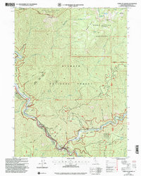
2001 Map of Forks of Salmon
USGS Topo · Published 2004About this map
The confluence of the North Fork Salmon River and South Fork Salmon River creates a focused hub of early 2000s human activity at Forks of Salmon. This mountainous region is defined by historical mining ventures and river-bottom flats. Evidence of the area's gold-seeking past is scattered across the terrain, from the Sauerkraut Mine in the west to the Dougherty Mine perched near Dougherty Bluff in the east.
Find a feature on this map
78 named features on this map. Tap any name to fly to it.
Don’t see what you’re looking for? This feature index may not catch every label — zoom into the map to look around manually.
Map Details
Editions of this 2001 Forks of Salmon Map
This is the sole edition of this map. No revisions or reprints were ever made.
Other maps of this area

1948 · Weed
USGS Topo · 1:250,000

1950 · Weed
USGS Topo · 1:250,000

1955 · Salmon Mtn
USGS Topo · 1:62,500

1955 · Cecilville
USGS Topo · 1:62,500

1955 · Sawyers Bar
USGS Topo · 1:62,500

1955 · Forks of Salmon
USGS Topo · 1:62,500

1958 · Weed
USGS Topo · 1:250,000

1963 · Weed
USGS Topo · 1:250,000

1974 · Orleans Mtn.
USGS Topo · 1:24,000
1977 · English Peak
USGS Topo · 1:24,000