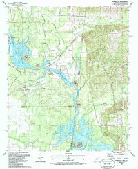
1987 Map of Forreston
USGS Topo · Published 1987About this map
The Tennessee-Tombigbee Waterway defines this landscape along the Mississippi and Alabama border in the late 1980s. This survey, updated from earlier aerial photography, captures the region following major hydrological changes, including the Hairston Bend Cut-Off and the formation of Aliceville Lake. The rural character of Lowndes and Pickens counties is preserved through several small communities and country churches, such as Mt Avery Ch and Smith Chapel. Local history is grounded in family and community landmarks like Toliver Cem and Spring Hill Cem. The presence of West Nashville Ferry Road points to an era of river crossing that predated the modern waterway infrastructure. Significant land use is noted through several disposal areas and gravel pits, while numerous creeks like Nash Creek and Coal Fire Creek feed into the transformed river system.
Find a feature on this map
44 named features on this map. Tap any name to fly to it.
Don’t see what you’re looking for? This feature index may not catch every label — zoom into the map to look around manually.
Map Details
Editions of this 1987 Forreston Map
This is the sole edition of this map. No revisions or reprints were ever made.
Other maps of this area

1953 · West Point
USGS Topo · 1:250,000

1958 · West Point
USGS Topo · 1:250,000

1960 · Columbus
USGS Topo · 1:62,500

1963 · West Point
USGS Topo · 1:250,000

1966 · Ethelsville
USGS Topo · 1:24,000

1966 · Reform SW
USGS Topo · 1:24,000

1970 · Aliceville North
USGS Topo · 1:24,000

1973 · Cliftonville
USGS Topo · 1:24,000
1974 · Pickensville
USGS Topo · 1:24,000

1984 · West Point
USGS Topo · 1:250,000