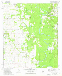
1974 Map of Pickensville
USGS Topo · Published 1975About this map
Pickensville sits on the high ground overlooking the Tombigbee River, serving as a central point for river and rail activity in the 1970s. The landscape is defined by the sharp transition between the floodplains of the river and the higher terrain of Ringo Bluff, where the St Louis-San Francisco railroad tracks follow the eastern bank. This era shows a settled agricultural region marked by numerous community institutions, including Pickensville Sch and several churches like St John Ch and Beebe Chapel. To the west, the boundary between Mississippi and Alabama cuts through the drainages of Indian Camp Creek and Owl Creek, where smaller settlements like Bigbee Valley and Aubrey maintain a quiet presence. Several family and community burial grounds, such as Upper Cem and Lower Cem, provide valuable landmarks for tracing local family history and rural settlement patterns.
Find a feature on this map
42 named features on this map. Tap any name to fly to it.
Don’t see what you’re looking for? This feature index may not catch every label — zoom into the map to look around manually.
Map Details
Editions of this 1974 Pickensville Map
2 editions found
Other maps of this area

1953 · West Point
USGS Topo · 1:250,000

1958 · West Point
USGS Topo · 1:250,000

1960 · Columbus
USGS Topo · 1:62,500

1963 · West Point
USGS Topo · 1:250,000

1966 · Reform SW
USGS Topo · 1:24,000

1970 · Aliceville North
USGS Topo · 1:24,000

1970 · Aliceville South
USGS Topo · 1:24,000

1973 · Cliftonville
USGS Topo · 1:24,000

1973 · McLeod
USGS Topo · 1:24,000
1974 · Dancy
USGS Topo · 1:24,000