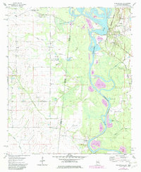
1974 Map of Pickensville
USGS Topo · Published 1982About this map
The Tombigbee River snakes along the Alabama-Mississippi border in this early 1970s survey, serving as the central artery for the region's transport and industry. On the eastern bank, Pickensville appears as a hub of local life, anchored by landmarks such as the Pickensville Rosewald Sch and nearby Upper Cem. The landscape is defined by the river’s heavy modification, evidenced by a prominent Lock and Dam and extensive spoil areas that signal the ongoing engineering of the Tenn-Tom Waterway.
Find a feature on this map
42 named features on this map. Tap any name to fly to it.
Don’t see what you’re looking for? This feature index may not catch every label — zoom into the map to look around manually.
Map Details
Editions of this 1974 Pickensville Map
2 editions found
Other maps of this area

1953 · West Point
USGS Topo · 1:250,000

1958 · West Point
USGS Topo · 1:250,000

1960 · Columbus
USGS Topo · 1:62,500

1963 · West Point
USGS Topo · 1:250,000

1966 · Reform SW
USGS Topo · 1:24,000

1970 · Aliceville North
USGS Topo · 1:24,000

1970 · Aliceville South
USGS Topo · 1:24,000

1973 · Cliftonville
USGS Topo · 1:24,000

1973 · McLeod
USGS Topo · 1:24,000
1974 · Dancy
USGS Topo · 1:24,000