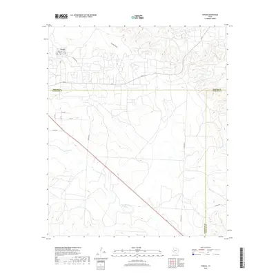
2019 Map of Forsan
USGS Topo · Published 2019About this map
Forsan sits in the northwest corner of this West Texas landscape, where the local grid of streets like Main St and Rex Ave centers on the local Po. The topography is defined by several significant drainage systems that carve through the high plains, most notably the N Concho River which cuts diagonally across the southern half of the map. To the north, the terrain is etched by Cannibal Draw and Dobson Cr, while Bull Cr drains toward the eastern boundary. This area marks a triple-county junction, with the convergence of Howard, Glasscock, and Sterling counties delineated across the open ranch land. A network of rural roads including Bowhunter Rd, Sisson Rd, and Overton Rd connects the scattered homesteads and provides access to the undulating terrain between the river valley and the northern draws.
Find a feature on this map
25 named features on this map. Tap any name to fly to it.
Don’t see what you’re looking for? This feature index may not catch every label — zoom into the map to look around manually.
Map Details
Editions of this 2019 Forsan Map
This is the sole edition of this map. No revisions or reprints were ever made.
Other maps of this area

1941 · Big Spring South
USGS Topo · 1:62,500

1942 · Big Spring South
USGS Topo · 1:62,500

1954 · Big Spring
USGS Topo · 1:250,000

1954 · San Angelo
USGS Topo · 1:250,000

1958 · San Angelo
USGS Topo · 1:250,000

1958 · Big Spring
USGS Topo · 1:250,000

1963 · Ballinger Ranch
USGS Topo · 1:24,000

1963 · Hayrick Mountain
USGS Topo · 1:24,000
1963 · Hyman
USGS Topo · 1:24,000

1963 · Garden City NE
USGS Topo · 1:24,000