
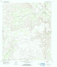
1963 Map of Garden City NE
USGS Topo · Published 1965About this map
The Clyde Reynolds Oil Field anchors the southern landscape of this West Texas terrain, marking the industrial footprint on the Permian Basin during the early 1960s. The map illustrates a transitional environment where the upper reaches of the North Concho River and Dobson Creek cut through the high plains, providing critical drainage in an otherwise arid expanse. Small-scale ranching and infrastructure are evident at Lester and the Foster Ranch, while the presence of the Big Spring City Wells and the Garden City Pumping Sta underscores the region's reliance on groundwater management. Surveyed just before the mid-sixties, the sheet also captures several industrial sites, including a series of Quarries and an extensive network of pipelines that traverse the rugged divide between Glasscock and Sterling counties.
Find a feature on this map
15 named features on this map. Tap any name to fly to it.
Don’t see what you’re looking for? This feature index may not catch every label — zoom into the map to look around manually.
Map Details
Editions of this 1963 Garden City NE Map
2 editions found
Other maps of this area

1941 · Big Spring South
USGS Topo · 1:62,500

1942 · Big Spring South
USGS Topo · 1:62,500

1954 · Big Spring
USGS Topo · 1:250,000

1954 · San Angelo
USGS Topo · 1:250,000

1958 · San Angelo
USGS Topo · 1:250,000

1958 · Big Spring
USGS Topo · 1:250,000

1963 · Glass Ranch
USGS Topo · 1:24,000

1963 · Ballinger Ranch
USGS Topo · 1:24,000

1963 · Hayrick Mountain
USGS Topo · 1:24,000

1963 · Currie Reservoir
USGS Topo · 1:24,000