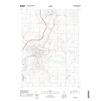
2018 Map of Fort Atkinson
USGS Topo · Published 2018About this map
Fort Atkinson and the southern edge of Jefferson anchor this Jefferson County landscape, where the Rock River winds through a complex network of wetlands and small aviation fields. The river's path is central to the area's geography, feeding into Haumerson Pond and meeting the Bark River just east of the city center. This 2018 survey reveals a modern mix of residential expansion and preserved memorial sites, including the Jefferson County Potter's Field Cem and the Rock River Cem. The map provides excellent detail for genealogists tracing family locations near the Evergreen Cem or the rural settlement of Cold Spring. Transportation is defined by a dense grid of county roads and a notable concentration of local air facilities like the Blackhawk Island Airport and Christie Aerodrome, reflecting the region's diverse light industrial and recreational character.
Find a feature on this map
146 named features on this map. Tap any name to fly to it.
Don’t see what you’re looking for? This feature index may not catch every label — zoom into the map to look around manually.
Map Details
Editions of this 2018 Fort Atkinson Map
This is the sole edition of this map. No revisions or reprints were ever made.
Other maps of this area

1891 · Waterloo
USGS Topo · 1:62,500

1891 · Koshkonong
USGS Topo · 1:62,500

1892 · Watertown
USGS Topo · 1:62,500

1892 · Whitewater
USGS Topo · 1:62,500

1893 · Whitewater
USGS Topo · 1:62,500

1894 · Waterloo
USGS Topo · 1:62,500

1894 · Watertown
USGS Topo · 1:62,500

1894 · Koshkonong
USGS Topo · 1:62,500

1903 · Whitewater
USGS Topo · 1:62,500

1906 · Koshkonong
USGS Topo · 1:62,500