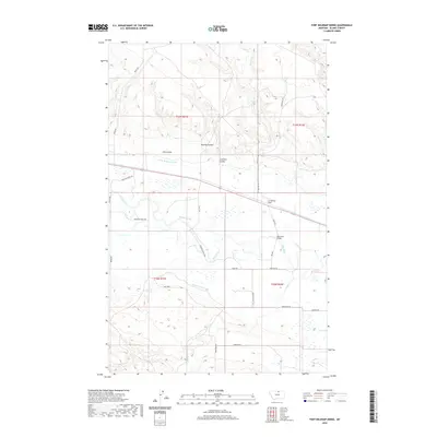
2020 Map of Fort Belknap Siding
USGS Topo · Published 2020About this map
The Milk River meanders across this northern Montana landscape, anchoring a complex system of hydraulic engineering designed for high-plains agriculture. Essential water management features like the Fort Belknap Canal, Harlem Canal, and Snake Cr Ditch illustrate the region's reliance on irrigation to support life and industry. The settlement of Fort Belknap Siding and the rural community of New Hope mark the human footprint in an area otherwise defined by drainage patterns such as Murphy Coulee and Zualtieri Coulee. The presence of the Milk River Bridge and a network of named local roads like Paradise Valley Rd and Norheim Rd provide a clear view of the transportation corridors that link these remote settlements. This survey reflects a modern era where traditional ranching and farming rely on a century-old infrastructure of canals and ditches.
Find a feature on this map
29 named features on this map. Tap any name to fly to it.
Don’t see what you’re looking for? This feature index may not catch every label — zoom into the map to look around manually.
Map Details
Editions of this 2020 Fort Belknap Siding Map
This is the sole edition of this map. No revisions or reprints were ever made.
Other maps of this area

1904 · Chinook
USGS Topo · 1:62,500

1905 · Harlem
USGS Topo · 1:62,500

1912 · Zurich
USGS Topo · 1:125,000

1913 · Cherry Ridge
USGS Topo · 1:125,000

1953 · Havre
USGS Topo · 1:250,000

1956 · Cleveland
USGS Topo · 1:62,500

1957 · Havre
USGS Topo · 1:250,000

1958 · Havre
USGS Topo · 1:250,000
1964 · Fort Belknap Agency
USGS Topo · 1:24,000
1964 · Big Coulee
USGS Topo · 1:24,000