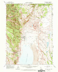
1962 Map of Fort Bidwell
USGS Topo · Published 1972About this map
Fort Bidwell sits at the foot of the Warner Mountains in this early 1960s survey, marking a historic transition between the high alpine peaks and the vast alkali flats of Surprise Valley. The map details the Fort Bidwell Indian Reservation and the town's immediate surroundings, including the Mt Bidwell Sch and a local airstrip. To the north, the terrain rises sharply toward the Oregon border, where the Fremont Mountains and Modoc National Forest house several mining operations such as the Modoc Mines, Klondyke Mines, and Consolidated Mines. This landscape is defined by its water management and transit, with the Fandango Pass Road crossing the range and a network of numbered creeks like Eightmile Creek and Twelvemile Creek feeding toward the basin. The eastern portion reveals the seasonal nature of the Great Basin, where Upper Lake and Cow Head Lake dominate the lowland flats.
Find a feature on this map
75 named features on this map. Tap any name to fly to it.
Don’t see what you’re looking for? This feature index may not catch every label — zoom into the map to look around manually.
Map Details
Editions of this 1962 Fort Bidwell Map
2 editions found

Other maps of this area

1886 · Alturas
USGS Topo · 1:250,000

1889 · Long Valley
USGS Topo · 1:250,000

1892 · Alturas
USGS Topo · 1:250,000

1954 · Vya
USGS Topo · 1:250,000

1954 · Alturas
USGS Topo · 1:250,000

1955 · Klamath Falls
USGS Topo · 1:250,000

1955 · Adel
USGS Topo · 1:250,000

1957 · Adel
USGS Topo · 1:250,000

1958 · Alturas
USGS Topo · 1:250,000

1958 · Klamath Falls
USGS Topo · 1:250,000