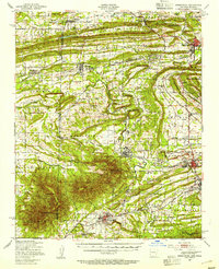
1977 Map of Fort Coffee
USGS Topo · Published 1977About this map
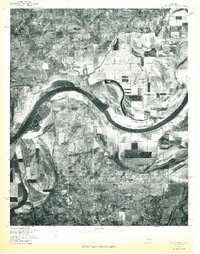
Arkansas River oxbows and the expansive alluvial plains of Paw Paw Bottom dominate this aerial perspective of eastern Oklahoma in the late 1970s. This orthophotoquad provides a literal view of the land use patterns near the settlement of Fort Coffee, where the transition from organized agricultural plots to the complex, shifting hydrology of the river is clearly visible. Small community centers and geographic markers like Baldridge, Cottonwood, and Murry Spur punctuate the landscape, offering specific points of reference for those studying the rural development of Le Flore County. The imagery, captured by the Geological Survey in cooperation with the Soil Conservation Service, documents the precise state of the riverbanks and timberlines before further decades of erosion and human activity altered these riparian corridors.
Find a feature on this map
6 named features on this map. Tap any name to fly to it.
Don’t see what you’re looking for? This feature index may not catch every label — zoom into the map to look around manually.
Map Details
Editions of this 1977 Fort Coffee Map
This is the sole edition of this map. No revisions or reprints were ever made.
Other maps of this area

1879 · Fort Smith
USGS Topo · 1:62,500

1887 · Van Buren
USGS Topo · 1:62,500

1887 · Greenwood
USGS Topo · 1:62,500

1890 · Fort Smith
USGS Topo · 1:125,000

1900 · Sallisaw
USGS Topo · 1:125,000

1911 · Sallisaw
USGS Topo · 1:125,000

1943 · Fort Smith
USGS Topo · 1:125,000

1946 · Fort Smith
USGS Topo · 1:250,000

1947 · Van Buren
USGS Topo · 1:62,500
1947 · Greenwood
USGS Topo · 1:62,500