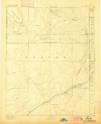
1892 Map of Fort Defiance
USGS Topo · Published 1900About this map
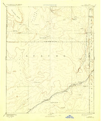
Fort Defiance serves as the focal point of this reconnaissance of northeastern Arizona, surveyed just years before the turn of the century. The landscape is defined by the critical junction of water and transport, with the Atlantic and Pacific RR tracing the course of the Rio Puerco through the southern portion of the territory. This rail corridor established a lifeline for small stops like Sanders, Navajo Springs, and Allantown, while the interior remains a vast expanse of high desert terrain marked by landmarks such as Salahkai Mesa and Zilh Tusayan Butte. The map clearly delineates the Navajo Indian Res. Line, showing the early administrative organization of the region. Local supply points like the Store near Allantown and reliable water sources such as Jacobs Well and Tanners Spring highlight the essential infrastructure for travelers and early settlers in this arid environment.
Find a feature on this map
32 named features on this map. Tap any name to fly to it.
Don’t see what you’re looking for? This feature index may not catch every label — zoom into the map to look around manually.
Map Details
Editions of this 1892 Fort Defiance Map
6 editions found
Other maps of this area

1883 · Marsh Pass
USGS Topo · 1:250,000

1883 · Tusayan
USGS Topo · 1:250,000

1886 · St Johns
USGS Topo · 1:250,000

1886 · Wingate
USGS Topo · 1:250,000

1886 · Tusayan
USGS Topo · 1:250,000

1886 · Fort Defiance
USGS Topo · 1:250,000

1886 · Holbrook
USGS Topo · 1:250,000

1889 · Chaco
USGS Topo · 1:250,000

1892 · Fort Defiance
USGS Topo · 1:250,000

1892 · Marsh Pass
USGS Topo · 1:250,000
Featured Places
- Chinle Agency, AZ
- Fort Defiance Agency
- Fort Defiance, Fort Defiance Agency
- Window Rock, Fort Defiance Agency
- Eastern Navajo Agency, NM