
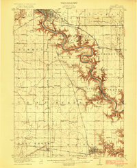
1958 Map of Fort Dodge
USGS Topo · Published 1958About this map
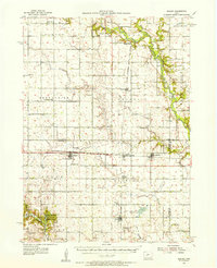
The Des Moines River carves through the eastern landscape of this mid-century survey, anchoring the industrial and transit hub of Fort Dodge. The area surrounding the city shows a cluster of smaller settlements like Coalville, Kalo, and Otho, reflecting the local mining and quarrying history that defined the river valley. To the west, the topography opens into the vast drainage basins of the Little Sioux River and the Boyer River, where the towns of Cherokee and Storm Lake serve as major regional centers.
Find a feature on this map
180 named features on this map. Tap any name to fly to it.
Don’t see what you’re looking for? This feature index may not catch every label — zoom into the map to look around manually.
Map Details
Editions of this 1958 Fort Dodge Map
This is the sole edition of this map. No revisions or reprints were ever made.
Other maps of this area

1911 · Madrid
USGS Topo · 1:62,500

1914 · Madrid
USGS Topo · 1:62,500

1916 · Boone
USGS Topo · 1:62,500
1923 · Lehigh
USGS Topo · 1:62,500

1923 · Fort Dodge
USGS Topo · 1:62,500
1950 · Perry
USGS Topo · 1:62,500
1951 · Perry
USGS Topo · 1:62,500
1951 · Ogden
USGS Topo · 1:62,500
1954 · Bagley
USGS Topo · 1:62,500

1954 · Fairmont
USGS Topo · 1:250,000